|
Norman island in one of the world's greatest tidal ranges
The largest of the Channel Islands, Jersey (117 km2) situated in the Bay of Mont St Michel, is little more than 20 km from the northwest coast of Normandy, France. The underlying geology is largely granite and shale. The overlying soils vary from areas of clay, sandy loess and alluvium with acid soils, particularly over the granite. The climate is milder than that of the British Isles with mean temperatures of 7°C in January and 18°C in August. Summers are generally warm and dry, yet with the occasional drought. Winters are usually mild but with frosts in some years. The island slopes from a height of 153 m on the north coast to 60 m above mean sea level in the south.
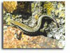
Jersey’s geographical position partly explains the large number (33) of UK Red Data Book species supported. Species include the four reptiles (two lizards, the green and wall [pictured] not found in the UK), two amphibians (including the agile frog [inset, main picture], which is not found in the UK), the red squirrel, several invertebrates rare or not recorded in UK, and a rich lichen flora, not to mention the rich marine life, such as red starfish (inset, main picture).
In 2010, a biodiversity strategy was published and can be downloaded here >>
Four sites have been designated under the Ramsar Convention, an international agreement that recognises Wetlands of International Importance; they are the South-East Coast (designated in 2000) and the offshore reefs of Les Minquiers, Les Ecrehous and Les Dirouilles, and Les Pierres de Lecq (designated in 2005).
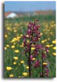
In addition to the inter-tidal, important habitats include dunes in the west and coastal heath-land on the southwest and north coasts. Additional planning protection is provided for the large, relatively undeveloped western coastal plain and scarp slopes. As well as the dunes and dune grassland the area contains the largest natural fresh-water body in the island: St Ouens Pond which is 4.5 ha, surrounded by 9.0 ha of reed beds. The associated wet meadows, with a rich orchid flora (loose-flowered or Jersey orchid [pictured]) and the dune grassland make this an exceptionally rich area.
Points to note are the high density of population (88,000 residents and approximately 600,000 visitors per year, with 20% of the area urban); the area of farmland, 54% of the Island; and the still considerable area (26% of the land) of semi-natural habitats. Jersey is extremely well connected to the outside world, because of the needs of the finance industry and tourism. However, there is a residual isolationist sentiment, political complacency and resistance to the responsibility to preserve biodiversity.
Non government organisations include the National Trust for Jersey (founded in 1936), an independent and charitable organisation dedicated to preserving and safeguarding sites of historic, aesthetic and natural interest for the benefit of the island, and La Société Jersiaise (founded in 1873) for the study of Jersey archaeology, history, natural history, the ancient language and the conservation of the environment.
|
 |
|